Rectory Farm, Godmanchester – Publication of the Report
 This article is reproduced with the kind permission of Oxford Archaeology East.
A book about the complex multi-period landscape excavated at Rectory Farm, Godmanchester has been published by East Anglian Archaeology. The site includes a Neolithic trapezoidal enclosure of national importance and a scheduled Romano-British villa. For details of the publication go to: http://eaareports.org.uk/publication/report170/
Oxford Archaeology East was commissioned by Historic England in 2013 to produce this monograph. The excavations at Rectory Farm, Godmanchester were undertaken between 1988-1995 by Historic England’s (formerly English Heritage) Central Archaeological Service in advance of gravel quarrying. Aerial photography had revealed a Neolithic trapezoidal enclosure of national importance and a scheduled Romano-British villa. The site lies within the valley of the Great Ouse, along which extensive prehistoric landscapes have been the subject of archaeological work for some time. Many of these sites have been excavated by OA East, including the complex of Late Neolithic and Early Bronze Age ceremonial monuments at Brampton.

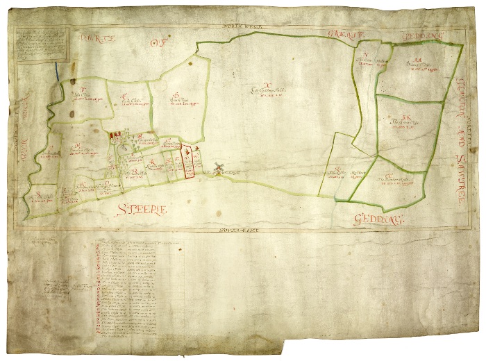
Copyright Godmanchester Museum (www.godmanchester.co.uk)
At Rectory Farm, the earliest activity was a large Early to Middle Neolithic monument consisting of a series of twenty-four large posts arranged with great precision and enclosed by a continuous ditch and internal bank with an ‘entrance’ on one side. A small mound further west evidently served as a viewing point for the trapezoidal enclosure. It is of unusual form and it is of particular interest in terms of its wider setting in a developing monumental landscape. Radiocarbon analysis dates the use of the enclosure to 3685-3365 cal BC (95% probability). This enclosure appears to be unique in the archaeological record and is therefore of national and international significance. The publication contains a major new analysis of its archaeoastronomical significance conducted by Professor Clive Ruggles of University of Leicester. The alignment of the posts with the early May and/or August sunrises suggests that the monument was used as a place for people to gather and mark the changing seasons, and possibly key points of the agricultural cycle.
This part of the Ouse Valley suffered regular flooding throughout the later Bronze and the Early to Middle Iron Age. Once the floodwaters had receded, the prehistoric remains influenced subsequent re-occupation of the landscape.
A Roman villa farm complex developed in three identifiable phases, linked by a road to the Roman town of Durovigutum (Godmanchester). Notable remains included a furnished cremation cemetery, set within a complex of gardens. One of these contained plant and tree species reminiscent of the Mediterranean style, while close to the cemetery and a possible triclinium (a dining area) was a kitchen courtyard garden with nearby bee hives. Three substantial wells nearby contained painted wall plaster, tesserae and a large column capital. The discovery of a finely made cockerel figurine within one of the wells may indicate an association with the god Mercury. By the early 5th century, the buildings were derelict, but although settlement had ceased the land remained in agricultural use until gravel extraction and landfill took place in the late 20th century.
The lead author was Alice Lyons, formerly of OA East. The project was managed by OA East’s Head of Post-Excavation & Publications, Liz Popescu, said “Oxford Archaeology is proud to have brought this major site successfully to publication – the results will undoubtedly be of interest to locals and academics alike.”
Brian Kerr, Head of Archaeological Investigation at Historic England said: “We are delighted to see the publication of a book about this important site, and we congratulate Oxford Archaeology East on the successful completion of the project that we funded. We are grateful to all our colleagues who contributed so much to the fieldwork, including a number of specialist analyses including human and plant remains, geoarchaeology and scientific dating.”
About Oxford Archaeology East:
Oxford Archaeology is one of the largest independent archaeological and heritage practices in Europe, with over 250 specialist staff working out of offices in Oxford, Lancaster and Cambridge. Founded in 1973, we have over 40 years of experience in professional archaeology, and a tradition of quality, innovation and service on projects ranging in scale from domestic extensions to international transport infrastructure. We are a registered educational charity, we help people to discover and enjoy their heritage through our publications and outreach. Across the country, we have welcomed many thousands of visitors to our sites on open days, regularly provide presentations and information panels, and volunteers of all ages have participated in our wide variety of excavation and survey projects that span all periods of human history. For further information, visit our website: www.oxfordarchology.com
Based in Cambridge, Oxford Archaeology East (OA East) operates primarily across the East of England from the Thames to the Humber. It has existed since the 1980s, previously as a local authority in-house contractor and since 2008 as part of Oxford Archaeology delivering commercial services for development projects and community archaeology opportunities.
About Historic England:
Historic England is the public body that helps people care for, enjoy and celebrate England’s spectacular historic environment, from beaches and battlefields to parks and pie shops. They protect, champion and save the places that define who we are and where we’ve come from as a nation. They care passionately about the stories they tell, the ideas they represent and the people who live, work and play among them. Working with communities and specialists Historic England share their passion, knowledge and skills to inspire interest, care and conservation, so everyone can keep enjoying and looking after the history that surrounds us all.